Turn-by-turn directions on Google Maps can turn an unfamiliar trip into a calm sequence of “turn right,” “keep left,” and “you have arrived.” The app guides drivers, walkers, cyclists, and public-transit riders while estimating arrival time, comparing routes, displaying traffic, and recalculating after a missed turn.
The basic process is simple: search for a destination, tap Directions, confirm your starting point, choose a travel mode, select a route, and tap Start. A few settings, however, determine whether you receive accurate positioning, spoken instructions, and dependable navigation when cellular service disappears.
Quick Steps to Start Turn-by-Turn Navigation
- Open the Google Maps app.
- Search for an address, business, landmark, or saved place.
- Tap Directions.
- Confirm that the starting point says Your location.
- Select driving, walking, cycling, transit, or another available mode.
- Review the suggested routes and tap the one you prefer.
- Tap Start.
Alternative routes normally appear as gray lines. Tap one to update the distance, estimated time, toll details, and traffic delay. Menu names can vary slightly by phone, region, and app version, but the main workflow is similar on Android and iOS.
Prepare Google Maps for Reliable Navigation
Allow Precise Location Access
On Android, open the phone’s settings, find Google Maps under Apps, choose Permissions, and allow location access while using the app. Android can combine GPS, nearby Wi-Fi, cellular towers, and device sensors to estimate location more accurately, particularly around tall buildings or indoors.
On iPhone, go to Settings > Privacy & Security > Location Services > Google Maps. Choose an appropriate permission, such as While Using the App, and enable Precise Location. Approximate location may find a nearby coffee shop, but precise location is better at deciding which side of the intersection you are actually standing on.
Check Data, Updates, and Safety
An internet connection is needed to search, calculate new routes, load live traffic, and suggest detours. Update Google Maps when possible, download offline maps before remote travel, and mount the phone where it is visible without blocking the windshield. Choose the destination before moving; a navigation app should reduce distraction, not become a dashboard escape room.
How to Get Turn-by-Turn Directions on Android
- Open Google Maps and enter the destination in the search field.
- Select the correct result, then tap Directions.
- Confirm Your location as the starting point, or enter another origin for trip planning.
- Choose a travel mode and compare the available routes.
- Tap Start.
During navigation, the top of the screen shows the next maneuver and the distance remaining before it. The map may also display lane guidance, traffic slowdowns, incidents, and alternate routes. Swipe up from the bottom panel to see trip details, search along the route, share progress, or view the complete step list.
How to Get Turn-by-Turn Directions on iPhone or iPad
Open Google Maps, search for the destination, tap Directions, verify the starting point, choose a travel mode, select a route, and tap Start. While navigation is active, use the speaker icon to choose full spoken guidance, alerts only, or mute.
When connected to CarPlay, adjust navigation volume with the vehicle’s controls while the guidance voice is speaking. Turning the knob during silence may change the music instead, which is useful only if your solution to a missed exit is a louder chorus.
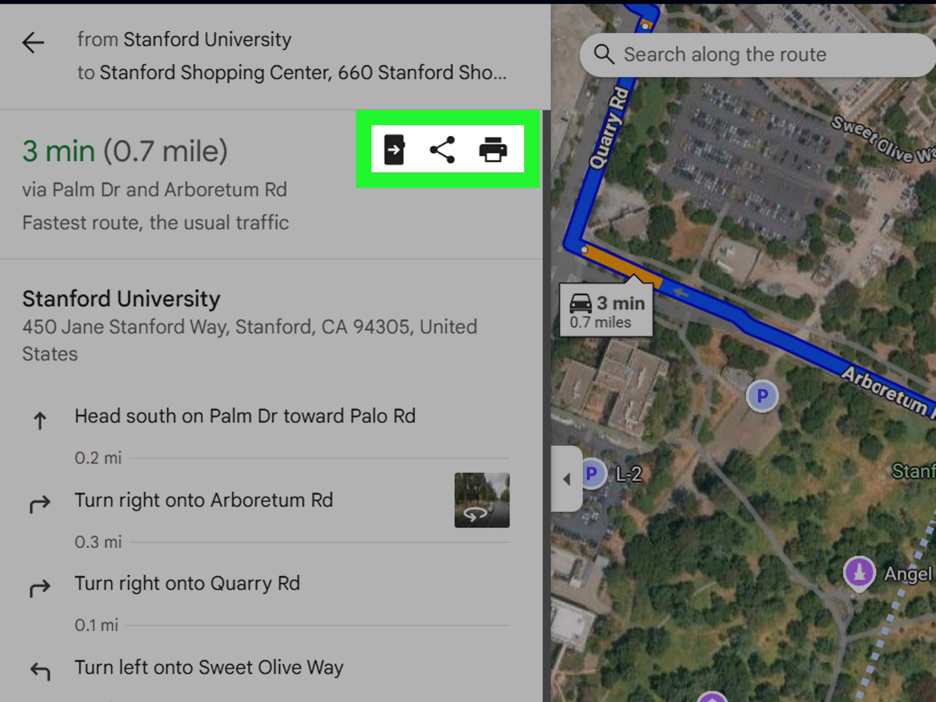
How to Plan Google Maps Directions on a Computer
- Open Google Maps in a browser and click Directions.
- Enter the starting point and destination.
- Select a transportation mode.
- Click a route to view written steps and available Street View previews.
- Share the route with your phone for live voice navigation.
Desktop Maps is useful for comparing routes, setting departure or arrival times, and planning complicated trips. You can add up to nine stops including the final destination for eligible travel modes. Multi-stop directions are not available for public transit or flight searches.
Customize Your Google Maps Route
Choose an Alternative Route
The recommended route is not a royal decree. Tap a gray alternative to compare time, mileage, traffic, tolls, and road type. A route that is two minutes slower may be more comfortable if it avoids a difficult interchange or crowded downtown streets.
Avoid Tolls, Highways, or Ferries
After requesting directions, open the three-dot menu or Options. Enable preferences such as Avoid tolls, Avoid highways, or Avoid ferries. Review the result because avoiding one road type may add substantial time. Fuel-efficient route preferences and vehicle profiles are also available in supported regions.
Add and Rearrange Stops
Open the route menu and choose Edit stops or Add stop. Add gas stations, hotels, stores, or pickup points, then drag them into the correct order. Google Maps supports up to nine stops including the final destination for eligible modes.
Search Along the Route
After navigation starts, swipe up on the trip panel and look for search options. Results for gas, food, parking, restrooms, or charging stations may show how much time each stop adds. Make selections while parked or ask a passenger to help.
How to Turn On Google Maps Voice Directions
Start navigation and tap the speaker icon. Select normal sound for every maneuver, alerts only for warnings without spoken turns, or mute for silence.
For a permanent volume change, tap the profile picture and open Settings > Navigation > Guidance volume. Choose Softer, Normal, or Louder. Android also offers voice and language controls through navigation or text-to-speech settings. On iPhone, navigation language can depend on the device language.
Fix Silent Voice Guidance
- Make sure the speaker icon is not muted or set to alerts only.
- Raise media volume while the navigation voice is speaking.
- Confirm that Bluetooth is connected to the correct car or headset.
- Select the correct audio source on the car stereo.
- Increase guidance volume in Google Maps settings.
- Restart the app or phone if the problem continues.
Bluetooth is a frequent culprit. The instructions may be playing perfectly through earbuds in a gym bag while the driver wonders why Google has suddenly taken a vow of silence.
How to Download Google Maps for Offline Navigation
- Connect to the internet and open Google Maps.
- Tap the profile picture and select Offline maps.
- Tap Select your own map.
- Resize the box so it covers the complete route area.
- Tap Download.
You can also open a place’s information panel and choose Download offline map when available. The entire route must fit inside the downloaded area. Offline Maps supports driving guidance, but offline transit, cycling, and walking directions are unavailable. Live traffic and alternate driving routes are also unavailable without a connection. Downloaded maps need periodic updates.
Walking, Cycling, and Transit Directions
After tapping Directions, choose the walking, bicycle, or transit icon. Availability varies by location and local data. Walking routes may include paths, stairs, crossings, and entrances that differ from vehicle access. In supported areas, Lens in Maps or Live View can use camera-based cues to help pedestrians choose the correct direction. Cyclists should still verify surface conditions, elevation, traffic exposure, and local restrictions.
Common Google Maps Navigation Problems
Preview Appears Instead of Start
Tap the starting-point field and select Your location. Then confirm that Google Maps has precise location permission. When the selected route begins somewhere else, Maps may offer a preview rather than live navigation.
The Blue Dot Is Wrong
Move outdoors, turn off Airplane mode, enable Wi-Fi or mobile data, and tap the blue dot for calibration options. Camera-based calibration may be offered on supported phones; otherwise, recalibrating the compass can help. Tunnels, garages, tall buildings, and heavy tree cover can weaken positioning.
The Route Looks Unreasonable
Check toll, highway, ferry, and fuel-efficient routing preferences. Verify the destination pin, especially for campuses, apartments, parks, and rural properties. Inspect the final approach with satellite imagery or Street View. For wilderness travel, unpaved roads, severe weather, or remote trails, confirm the route with official local information or a specialized map. A blue line is useful, but it is not permission to drive through a closed gate or flooded dirt track.
Google Maps Keeps Rerouting
Maps recalculates when traffic changes or the phone appears to leave the route. Weak GPS can make the blue dot jump onto a nearby road. Improve location accuracy and keep the phone where it has a clearer view of the sky. Never study a new route proposal while driving; follow the audio or stop safely.
Practical Tips for Better Directions
- Confirm the street, city, ZIP code, and entrance.
- Preview the final turns before leaving.
- Check traffic even on familiar trips.
- Download offline maps for remote or international travel.
- Carry a charger because GPS, data, Bluetooth, and the screen use power.
- Obey signs, closures, police instructions, and actual road conditions over the app.
Real-World Experiences With Google Maps Turn-by-Turn Directions
The biggest lesson from everyday navigation is that getting directions is easy; getting the right version of those directions requires a few seconds of preparation. Consider a driver visiting a large medical center. Typing the hospital name may produce a route to the official street address, but that pin could lead to the main lobby while the appointment is in a separate outpatient building. Checking the parking entrance and final two turns before departure can prevent a stressful loop around the property.
A similar experience happens on a daily commute. A person may know every turn and still start Google Maps because the app’s real value is monitoring current conditions. A crash, construction zone, sporting event, or disabled vehicle can transform a normal 25-minute drive into a 50-minute crawl. Starting navigation before leaving lets the driver compare routes while parked instead of discovering the delay after joining a parade of brake lights.
Audio settings matter more than beginners expect. Imagine starting a road trip, hearing the first instruction clearly, and then losing the voice after the phone connects to the car. The map still works, but the audio has moved to Bluetooth while the stereo remains on another source. Switching the stereo to Bluetooth, selecting full sound instead of alerts only, and adjusting volume while the voice speaks usually solves the mystery.
Offline maps create another important difference. In a city, losing service briefly may barely matter. In a rural area, canyon, national park, or foreign country, weak data can prevent a new route from loading exactly when it is needed. Downloading a map that covers the origin, destination, and surrounding roads provides a practical backup. The limitation matters too: offline driving directions do not include live traffic or alternate routes, while offline walking, cycling, and transit directions are unavailable.
Walking directions produce their own small comedy. GPS may place a pedestrian on the correct block while the phone’s compass points backward. The result is the classic sidewalk shuffle: walk 20 feet, stare at the blue dot, turn around, and repeat. Pausing for calibration, looking for landmarks, and previewing the next two steps works better than immediately trusting a rotating arrow.
Multi-stop trips show why route order matters. Adding a grocery store, gas station, and pickup address is convenient, but Google Maps does not know every priority. A store may close early, a passenger may need to be collected first, or fuel may be required before a long highway segment. Rearranging stops and checking the total route prevents the app from creating an efficient mathematical answer to the wrong practical problem.
Experienced users also learn not to treat the blue route as unquestionable truth. Temporary construction, a private entrance, an unpaved road, or dangerous weather deserves more trust than a screen based on imperfect data. Google Maps is a capable co-pilot: helpful, fast, occasionally brilliant, and still not the one holding the steering wheel.
Conclusion
To get turn-by-turn directions on Google Maps, search for a destination, tap Directions, confirm Your location, select a travel mode and route, and tap Start. For more reliable navigation, enable precise location, turn on spoken guidance, review route options, and download offline maps before entering low-signal areas.
Google Maps works best when paired with preparation and common sensetwo features that, fortunately, do not require another software update.
Note: Menu names and feature availability may vary by device, Google Maps version, vehicle system, country, and transportation mode. This guide was verified against current Google Maps Help, Android Help, Android Auto Help, Apple Support, Google product documentation, and established U.S. technology publications in July 2026.