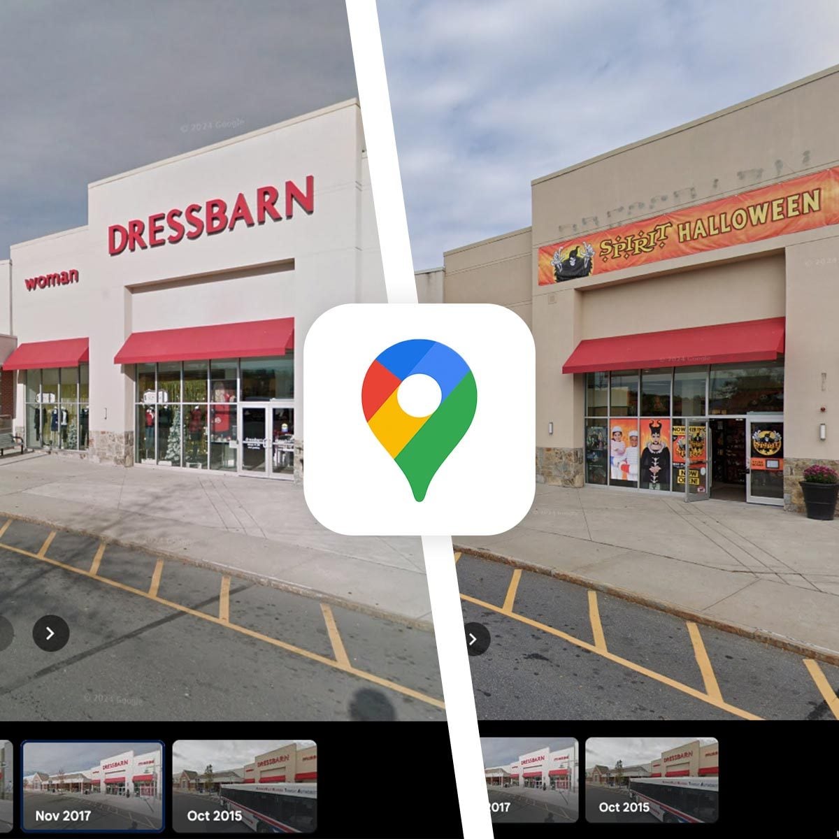
Google Maps is already the app we open when we are lost, late, hungry, or trying to prove to someone that, yes, the coffee shop really is “right there on the corner.” But hidden inside Street View is one of its most fascinating features: the ability to look up old photos on Google Maps and see how a place changed over time.
Maybe you want to revisit your childhood home. Maybe you are researching what a neighborhood looked like before a new apartment complex appeared. Maybe you are trying to remember whether that taco place used to be a dry cleaner, a dentist’s office, or one of those mysterious stores that only sold phone cases and vibes. Whatever the reason, Google Maps historical Street View can feel like a tiny time machine sitting inside your browser or phone.
This guide explains exactly how to find old Google Maps photos, how to use historical Street View on desktop and mobile, when to switch to Google Earth, and what to do when the “See more dates” option does not appear. No lab coat required. A little curiosity helps.
What Are Old Photos on Google Maps?
When people say they want to see “old photos on Google Maps,” they are usually talking about historical Street View imagery. Street View is the street-level, 360-degree photography feature inside Google Maps. It lets you stand virtually on a road, sidewalk, trail, or public space and look around as if you were there.
Over the years, Google has collected new Street View images in many places. When a location has been photographed more than once, Google may store those earlier images in an archive. That archive is what allows you to look back at previous versions of the same street, building, business, or neighborhood.
In practical terms, historical Street View can show you things like:
- How a house looked before renovations
- What a business storefront looked like in a previous year
- How a neighborhood changed after new construction
- Older signs, roads, trees, sidewalks, and landmarks
- Past views of places connected to family memories
It is important to understand one limitation: Google Maps does not provide historical Street View for every location. If Google only captured that street once, or if older imagery is unavailable, you may only see the current view. In other words, the time machine works beautifully in some places and politely shrugs in others.
How To Look Up Old Photos on Google Maps on Desktop
The easiest way to view old Street View photos is usually on a computer. The desktop version gives you more screen space, easier controls, and a clearer view of the date options.
Step 1: Open Google Maps in Your Browser
Go to Google Maps on your desktop browser. Chrome works well, of course, but other major browsers can also handle Street View. Once the map loads, use the search bar to find the address, landmark, business, or neighborhood you want to explore.
Step 2: Enter Street View
There are a few ways to open Street View. You can click the small Street View preview image if it appears in the location panel. You can also drag the yellow Pegman icon onto a blue-highlighted road. Blue lines indicate areas where Street View imagery is available.
Once you drop Pegman onto a blue line, the screen will switch from map view to street-level imagery. You can now rotate, zoom, and move along the street.
Step 3: Look for the Date or “See More Dates”
In Street View, look near the information box that displays the location and image date. Depending on the current interface, you may see a small clock icon, a date, or a “See more dates” option. Click it.
If historical imagery is available, Google Maps will show a timeline or a carousel of older Street View photos. Each option usually includes a month and year. Select one, and the view will change to that older image. Suddenly, the brand-new smoothie bar may become a 2012 laundromat. Progress is mysterious.
Step 4: Compare Different Years
After selecting an older image, look around the scene. You can compare changes in buildings, roads, landscaping, street signs, business names, parked cars, or nearby construction. To return to the newest image, choose the latest date in the timeline or exit and reopen Street View.
How To Look Up Old Photos on Google Maps on iPhone and Android
Google Maps historical Street View also works on mobile in many locations. The exact layout can vary slightly between iPhone and Android, but the general process is similar.
Step 1: Open the Google Maps App
Open Google Maps on your phone and search for the place you want to view. You can search for a full address, a business name, a landmark, or simply press and hold on the map to drop a pin.
Step 2: Open Street View
If a Street View thumbnail appears, tap it. You can also tap the Layers button, select Street View, and then tap a blue line on the map. Blue lines are your invitation to step into the street-level view without actually leaving your couch.
Step 3: Tap “See More Dates”
Once Street View opens, tap the screen or look for the “See more dates” option. If it appears, tap it. A row of available historical images should appear at the bottom. Swipe through the dates and choose the one you want.
If the option does not appear, that does not necessarily mean you did something wrong. It usually means historical images are not available for that exact spot, or the app is not showing them for that location.
Why “See More Dates” Does Not Always Show Up
The most common frustration with old Google Maps photos is simple: people know the feature exists, but they cannot find it. The reason is usually availability.
Historical Street View depends on several factors:
- Whether Google captured that location more than once
- Whether older images are still available in the archive
- Whether the selected spot is on a blue Street View line
- Whether you are viewing official Street View or a user-contributed photo
- Whether privacy, quality, or coverage limitations affect the imagery
Try moving a few steps down the street. Sometimes one exact point has no older dates, while another spot nearby has several. Also try the desktop version if the mobile app does not show the archive. Desktop can sometimes be easier for exploring older imagery because the interface gives you more room to work.
Google Maps vs. Google Earth: Which One Should You Use?
Google Maps is best when you want old street-level photos. If your goal is to see what a house, storefront, road, or corner looked like in previous years, start with Google Maps Street View.
Google Earth is better when you want historical aerial or satellite imagery. It can help you see larger landscape changes, such as new subdivisions, shrinking lakes, road expansions, wildfire damage, construction projects, or urban development over time.
Think of it this way: Google Maps Street View is for standing on the street and looking at the front door. Google Earth is for flying above the neighborhood like a very responsible digital bird.
When Google Earth Helps More
Use Google Earth historical imagery when you need a wider view. For example, if you want to see when a shopping center was built, when farmland became a subdivision, or how a shoreline changed, aerial imagery is more useful than Street View. Street View may show the front of a building, but Google Earth can show the whole development pattern.
Best Uses for Old Google Maps Photos
Historical Google Maps images are more than a nostalgia toy. They can be surprisingly practical. Here are some of the most useful ways people use old Street View photos.
1. Revisiting Childhood Homes
One of the most emotional uses is looking up a childhood home. A past Street View image may show an old paint color, a family car in the driveway, a tree before it was cut down, or a front porch that no longer exists. It is not the same as opening a family album, but it can unlock memories in a way that feels unexpectedly powerful.
2. Checking Property Changes
Homeowners, renters, buyers, and real estate researchers can use historical Street View to see how a property changed. You might spot old fencing, roof changes, landscaping updates, driveway work, or exterior renovations. It is not a replacement for an inspection, but it can provide visual context.
3. Researching Local History
Old Google Maps photos can help document neighborhood change. A small-town main street may show businesses coming and going. A city block may reveal new bike lanes, taller buildings, wider sidewalks, or vanished murals. For local bloggers, historians, students, and journalists, these images can provide helpful clues.
4. Finding Former Businesses
Have you ever said, “What used to be here?” Google Maps may have the answer. Historical Street View can show old storefront names, signs, window decals, and awnings. This is especially useful in areas where restaurants, salons, shops, and offices rotate faster than everyone’s streaming subscriptions.
5. Tracking Construction and Urban Growth
If you are curious about when a building appeared, when a road changed, or how a neighborhood grew, historical imagery gives you a visual timeline. It can be useful for urban planning research, school projects, neighborhood associations, or anyone who enjoys saying, “Back in my day,” even if “my day” was 2019.
Tips for Better Results When Searching Old Google Maps Photos
Finding old images can take a little experimenting. These tips will help you get better results faster.
Search by Address First
Start with the most specific address you have. A full street address is better than a general neighborhood name. If the exact address does not show older dates, move around nearby roads using Street View arrows.
Try Multiple Spots on the Same Street
Street View is captured in segments. One spot may have only one date, while another position nearby may have several. Move forward, backward, or across the street and check again.
Use Desktop for Detailed Research
Mobile is convenient, but desktop is often better for careful comparisons. The larger screen makes it easier to read signs, compare building details, and switch between years.
Check Nearby Intersections
If a house or business does not show older dates, check the nearest intersection. Intersections are often captured from multiple directions, which can give you a usable angle of the same property.
Remember That Dates Are Approximate Context
Street View labels usually show the month and year the image was captured. That is helpful, but it is not a perfect historical record. Use it as visual evidence, not as a legal document carved into stone by the gods of cartography.
Privacy and Blurring in Old Google Maps Photos
Google Street View automatically blurs faces and license plates in many images. Some homes, people, vehicles, or sensitive locations may also be blurred. If something is blurred in a current image, it may also be blurred in older imagery. In some cases, older images may be unavailable or limited because of privacy, quality, or policy reasons.
This matters when you are looking for family memories. You may find a familiar house, but people or cars may not be clearly visible. That can be disappointing, but it is also part of why Street View can exist at such a large scale without turning into the world’s creepiest scrapbook.
Can You Download Old Google Maps Photos?
Google Maps does not work like a regular photo album where you can simply download an old image as your own. You can view historical imagery inside the platform, and you can usually share the Street View link. Screenshots may be possible on your device, but you should respect Google’s terms, copyright rules, and privacy considerations if you plan to publish or reuse images.
For personal memory research, viewing the image is usually enough. For commercial, editorial, academic, or legal use, make sure you understand the rules before relying on or republishing imagery.
Common Problems and Quick Fixes
Problem: I Cannot Find Street View
Make sure you are selecting a blue line or a location with Street View coverage. Some private roads, rural areas, trails, or newly developed neighborhoods may not have imagery.
Problem: There Are No Old Dates
Try moving to another nearby point. If there is still no “See more dates” option, older imagery may not be available for that location.
Problem: Mobile Does Not Show the Feature
Update the Google Maps app and try again. If the feature still does not appear, use the desktop version in a browser. Desktop is often the better tool for detailed historical Street View searches.
Problem: The Image Is Too Blurry
Older Street View images may have lower resolution than newer ones. Try another date, another angle, or a nearby point on the same street.
Experience-Based Reflections: Why Old Google Maps Photos Feel So Personal
Looking up old photos on Google Maps sounds like a simple tech trick until you actually do it. Then it becomes something stranger and more human. A street corner from 2011 can feel like a postcard from a version of your life that forgot to say goodbye.
One of the most common experiences is the “wait, that used to be there?” moment. You search an old address, open Street View, tap through earlier dates, and suddenly a forgotten restaurant appears. The sign is faded, the parking lot is half empty, and the whole image has that slightly soft, older-Street-View look. It may not be beautiful photography, but it has a quiet documentary power. It captures ordinary places before anyone knew they would become memories.
For families, the experience can be even stronger. People often look up the homes of grandparents, childhood neighborhoods, or streets where they used to walk to school. Sometimes they find small details: a basketball hoop by the garage, a dogwood tree in bloom, holiday decorations, or an old car in the driveway. These are not polished family portraits. They are accidental background details, which somehow makes them feel more honest.
There is also a practical side to the experience. If you are moving to a new area, old Google Maps photos can show whether a neighborhood has been improving, declining, or simply changing personality. You might notice fresh sidewalks, new businesses, renovated homes, or increased traffic. For small business owners, historical Street View can reveal how a commercial strip has evolved. For homeowners, it can show how landscaping and exterior updates changed curb appeal over time.
The feature is also a reminder that places are not frozen. A block that looks permanent today may have looked completely different ten years ago. Empty lots become apartments. Gas stations become coffee shops. Quiet streets gain bike lanes. Murals disappear. Trees grow taller. The world edits itself constantly, and Google Maps happens to keep some of the draft versions.
Still, the best way to use old Google Maps photos is with realistic expectations. You may not find the exact year you want. You may not get the perfect angle. A person you hoped to see may be blurred, absent, or never captured. But when the archive does work, it can be surprisingly moving. It gives you a way to revisit places that changed, check details you forgot, and understand that even the most ordinary street has a history. Sometimes the past is not hidden in a museum. Sometimes it is parked quietly behind a “See more dates” button.
Conclusion
Learning how to look up old photos on Google Maps is simple once you know where to look. Open Street View, find the date or “See more dates” option, and explore the available timeline. On desktop, the process is especially smooth. On mobile, the feature is convenient when available. And when you need a broader view of land, construction, or environmental change, Google Earth can be the better tool.
Historical Street View is useful for nostalgia, research, real estate curiosity, local history, and plain old “what was this place before?” detective work. It will not show every location or every year, but when it does work, it can turn a familiar street into a surprisingly rich visual archive. Google Maps may be famous for getting us where we are going, but its old photos can also show us where we have been.